26 Nights / 27 Days
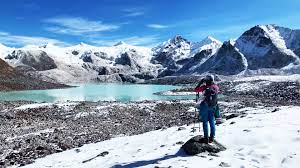
On arrival at Paro airport, you will be met by our representative. They will lead you to your hotel. By evening we will visit the Paro market and town and Spending the overnight at the hotel in Paro.
The next morning we will visit to Ta Dzong, built in 1651 as a watchtower. Later it was inaugurated as Bhutan’s National Museum. The collections in the museum include art, relics, religious thangkha paintings, postage stamps, coins and handicrafts, as well as a small natural history collection. After which we will visit the Rinpung Dzong (Paro Dzong), ‘the fortress of the heap of jewels’, built in 1646, and now housing the offices of the district administration and Paro’s monk body.
After lunch we will visit one of the oldest and sacred shrines in Bhutan knows as Kyichu Lhakhang which was built by the Tibetan king, Songtsen Gampo in the 7th century.
Distance 6 km
Estimated time 4 hrs
Our trek begins after a short drive of approx 20 minutes up the Paro valley to Drukyel Dzong. On this scenic drive we pass through farm country made up of fields of rice, wheat, barley, mustard, potato, and radish as well as herds of cows. We get our first views of the summit of Jomolhari (7314m) at the head of the valley. Initially the trail is wide and flat, as it meanders steadily through lightly forested fields, which in recent years have been the site of the ongoing large-scale Bhutan Government project to bring electricity to the isolated villages further up the valley. After a whole day experience of Traditional Bhutan we overnight camp at Shiring Karup.
Distance 12 km
Estimated time 5 hrs
Our 2nd day of trek will be within Jigme Dorje National Park, the largest protected area in the country (4350 sq kms.).The park consists of an amazing variety of species of plants and animals, both from high and low altitudes. The forest holds variety of oaks, maple, birch, larch pine and allders with unlimited rhododendron and pines as we trek higher. Many of our campsites will be at the wildness where we find few or no settlement. This is the chance to get close to our mother nature.
Distance 13.6 km
Estimated Time 4-5 hr
The next day we will move to the foot of Jomolhar in a wonderful alpine environment. Jichu Drake (6,794m) rises on the right and elegant ridge descends to the gorge that we will cross during the next day. We camp near the yak farmers of the Paro Valley. Who lives in tents made of woven yaklan. Now we are above the tree line and the area is characterized by low tundra of junipers and rhododendrons, blue sheep have also been encountered on the higher rock outcrops.
An important day set aside to rest, recollect and adapt to the surrounding. We will have a short trip for side seeing of some glacier, passes and lacks.
Distance 15 km
Distance 7 hr
For this day we will be climbing up to an altitude of 4850 meters and finally camp at 4010 meters. We start our journey through rolling slopes of grassland and small brush. After crossing the Nyile La we leave Jomolhari and Jichu Drake behind and make a steep descent through stands of pure rhododendron to the outskirts of Lingshi village. The beauty of Lingshi Dzong stands out which built to protect this and the other outlying villages of Bhutan from the periodic raids from Tibet.
Distance 11km
Estimated time 4-5 hr
We continue heading northeast, ascending past Lingshi Dzong in alpine pastures full of rhododendron and daphnias to Chebisa. It is a charming valley of pastures and stone houses with stone roofs. At its summit, a short walk from camp, is a tall waterfall cascading down a rocky cliff, behind which is suspected a hanging lake. Below are very tall, gnarled junipers. Above Chebisa are alpine pastures of blue sheep (or bharal).
Distance 12 km
Estimated time 7-8 hr
From Chebisa the trail contains undulating ups and downs to the Gombu La (4440 metres). The views back to Lingshi and the surrounding peaks are spectacular. Here, hill partridges have been sighted, while the lammergeier is seen soaring above the alpine pastures. The descent to our camp beside some yak herder camps at Shomuthang is through a forest of cypress then spruce and birch with large stands of rhododendron - griffithianum and campylocarpum. Iris and edelweiss may also be in flower. Our camp will most likely be beside the river, with soaring mountains at the head of the valley. But we may also hike up the valley an hour to make tomorrow’s hike easier.
Distance 9 km
Estimated time 6-7 hr
Our route this morning takes us straight up, crossing grassy slopes and windy hills to Jare La. Blue sheep and lamerjeras are often seen here. In the gap marked by flags and several fish, we can have a wider view of the adjacent valley and the next node, Sinche La. The trail winds low through alpine roses, spruces, cypresses and birches to a wide valley floor where yaks can be seen. This may be our first encounter with the people of Laya, who are distinguished by their strange woven conical hats with spikes on top and colorful beads behind. We walk a few hundred meters up the opposite side of the valley to our camp in Robluthang Hollow
Distance 14 km
Estimated time 7-8 hr
The ascent of Sinche La takes about four hours. A slow steady pace is essential to getting comfortable and getting through the long descent on the other side. The gorge itself has a glimpse of the peaks on the left, including the Gangchenta. Descending through rocks and grassy slopes opens up unprecedented views. Tiger Rails Beneath the dramatic peaks of the Gangchenta lie glacial blue lakes and white streams. Still further down, classic glacial erosion is at work and the valley floor is filled with fresh lateral and terminal moraines and an enormous milky gray lake. The forests are thick here and our beautiful camp by the river is surrounded by very tall conifers with Tiger Ears as a backdrop.
Distance 11 kms
Estimated time 4 hrs
This morning we will descent to Zamdo Nangi Chhu valley to Laya , walking away from the mountain environment before us. There are approximately 1,000 inhabitants in this high set village, and there is a school, Basic Health Unit, several small shops and a gompa (temple) to meet their needs. Life is not easy in this cooler, isolated location that is snowed in during winter. Much of their living is reliant on yaks (meat, wool and dried cheese), and one annual crop of barley, mustard and turnips. Above us to the east are spectacular views ahead to Masang Gang (7194m) and toward the region of Lunana where we will trek for the next 12 days. Prevailing snow conditions will be influential to our journey, as Lunana gets snowed-in at cold times of the year, and your guides will do their best to achieve our trip program without compromising safety. Furthermore, with good luck, we will be able to synchronies our change of animal porter age sometime soon after our arrival and we can head off on the trail the next morning.
Some time to relax is most welcome after the exertions of the past few days. After a leisurely start to the day, we will enjoy some additional visiting time in Laya, threshing wheat with the ladies, visiting the school or perhaps enjoying a tea in one of the small shops.
Distance 18 kms
Estimates time 7-8 hrs
We start the trek early as today is one of the hardest days with many steep climbs. After passing the military camp and crossing the river, we begin the ascent to Lunana and the further stages of the journey. It takes more than three days to reach Woche, the first Lunan settlement. The forest is lush and the steep path winds between tall trunks and root stumps. As we climb higher, we walk among pines, oaks and rhododendrons, and finally ascend to a river valley of wide alpine pastures. The valley is surrounded by steep slopes and rocky cliffs, and since we are now higher, our night camp is cooler.
Distance 11 kms
Estimates time 6-7 hrs
We steadily ascend the slopes of dwarf rhododendrons, and, trek on through another small valley of alpine pastures to a small pass, Tsemo La (4905 m). We descend and traverse around some slopes to be rewarded with a line of snowy peaks where we can see Gangla Karchung (6395m) the highest. Our camp is on grassy slopes, surrounded by glaciers, moraines and a few small alpine lakes.
Distance 16 kms
Estimated 8-9 hrs
Today's amazing walk takes us to the untouched and remote Lunana region. It takes us about an hour and a half to reach the pass at the top of the valley and then we have a very long descent of about 1200 meters into the Tang Chuu Valley. The peaks of Karakachu La (5165 m), Jejekanhphu Gangi (7300 m) and Tsenda Kangi (7100 m) can be seen to the left of Kura. These dramatic peaks feed the lakes, hanging glaciers and river systems that lie ahead. We descend along the side moraine and then through the rhododendron forests to the bottom of the valley, where we walk another 2-3 hours to our camp, which is located in the opening downstream. Please note that late lunch may be served at an additional charge. It is recommended to bring some small snacks with you to keep energy levels high during this longer days.
Distance 14 kms
Estimates time 7 hrs
Along the river we descend into the valley to see the effects of several large landslides. They took away patches of forest and left behind a huge pile of rubble. We climb across the ridge to the village of Woche, the first Lunana village, located at an altitude of 3940 meters. We can see families all helping to thresh wheat or buckwheat in the fields with traditional turning sticks. We continue our journey, cross the river and climb through the dwarf rhododendron to tomorrow's pass. Time to relax and enjoy the view of the cricket-like valley we just passed through. Every day of trekking in this remote Bhutanese wilderness should be enjoyed as no two days are the same.
Distance 20 kms
Estimated time 8-9 hrs
Our trek gets easier as we had made most of our ascent yesterday; we only have approx 200 meters to trek to the gap of the Keche La (4670m). There is time to relax and enjoy the views across the cirque like valley that we have just passed through. Turning towards our destination, we see distant unnamed peaks but have to descend continually to Thega village and the river of the Pho Chuu, one of the principal rivers of Lunana. The temperatures are warm here and we trek leisurely beside the river and sometimes in the river bed, past the small village of Lhedi and on to Chozo. Our camp by the river offers 360 degrees of incredible views. Both Chozo and Thanza are considered the two main villages of Lunana, both are set before a spectacular array of mountains; the most dominating is Table Mountain (7100 m) that has an expansive summit that seems to stretch for kilometers. We haul our night at Chozo.
It’s time to relax and get refreshed. Perhaps go for a walk up the moraine, to the glacier near Table Mountain. There is a small ridge behind the village that offers spectacular views of the neighbour of Table Mountain, Kangphu Gang (7212m). You can also snap pictures of Chozo Dzong but, according to legend, the dzong is haunted and you should not make loud noises, go inside or step foot in its courtyard!
Distance 14 kms
Estimated time 9 hrs
There are two solid days of hiking ahead in an area where the weather can easily change from sun to snow to blizzard and we need to be well equipped for all conditions. Crossing the river first, we begin a steep ascent to Sintia Laa, 5140 meters high, from a long cliff and a narrow dwarf valley. The trip takes about four hours, but the views back to Lunana are amazing. More of a passage than an opening, the course is long and rugged, almost like a moonscape of rocks and plateaus interspersed with small glacial lakes and surrounded by a dazzling array of peaks. Stay close to your guides and fellow travelers as fog can quickly form and make visibility difficult. The camp is located on a desert plain where blue sheep or woodpeckers can be seen. Previous trekking groups have reported seeing a family of snow leopards here. We will not go to Tshochena via Thanza due to time constraints.
Distance 10 kms
Estimated time 5-6 hrs
The trail undulates between snow-capped peaks and crosses the Loju La (5100m). Winding around several ridges the views expand before us. Few, if any, of these peaks have ever been climbed, making our panorama all the more special. We camp in a little patch of grassy tundra, wedged between barren rocks and trickling streams.
Distance 15 kms
Estimated time 8-9 hrs
Leaving our yak herding camp along the pass, we walk through a lunar landscape of rocks, incredibly green lakes, glaciers and snowy peaks. Today we cross our highest pass, Rinchen Zoe La (5,326m), before crossing the Tibetan Plateau and descending to our camp, located in a forest clearing by the river. It takes about 2 hours to get the pass and the views on the final approach are incredible. Huge glaciers descend from a range of snow-capped mountains to two large ice-age blue lakes filled with small "icebergs"; A photographer's dream. Sometimes we take time to take pictures and evaluate our achievements and then continue camping. The hike to the camp involves a steep descent into a moraine and cliff jumping along the river where our camp is located.
Distance 15 kms
Estimated time 6-7 hrs
After crossing the river, we go into the main valley, entering the forest and warmer temperatures. The scenery is beautiful, both immediately around us and on the snowy peaks of the distant valley. The trail weaves in and out of the river and along rocks before entering a dense tall forest of pine, rhododendron, birch and maple. It is soft underfoot; mosses and mud now reflect moisture. A solid day of hiking brings us to camp just below our last flag. We wind through the forest along a narrow valley to a hanging lake or tarn, this ascent is continuous and steep with a noticeable rise. However, we got a beautiful environment as a reward for our last lakeside mountain camp.
Distance 12 kms
Estimated time 7-8 hrs
We need less than an hour and a half to reach Tempe La (4665m), the last pass of our trek. From there, the trek goes down to the camp. It is quite steep at first, winding down and past the great turquoise Om Tsho Lake, then back and forth over cliffs to the valley floor. From here to Marothang we go along the Nikka Chhu River through alpine and pine forests and yak pastures along fairly flat terrain. Be careful when walking, as rhododendron roots are often hidden by moss and overgrowth. In Marothang we meet the first shop after Laya, a sweet wooden house by the river. If we use jackets, we will switch to horses tomorrow for the last day.
Distance 15 kms
Estimated time on foot 4-5 hrs and 2 hrs by drive
The trail follows the Nikka Chhu through thick, lush forest that is cool and pleasant. We emerge into bamboo thickets and patchwork hillsides of crops and houses of the Sephu district. Our transport meets us at the trailhead and we drive about two hours to our overnight accommodation in Punakha. The end of this extraordinary trek and time to get back to civilization!
Our aim is to start the drive from Punakha to Paro early. Have a relaxing day and go for side seeing.
Trip concludes in the morning after breakfast.
Eden Eco Expedition, based in Bumthang (Bhutan), is a tour and travel company that provides complete travel solutions to travelers visiting Bhutan. We can take care of everything on your Bhutan trip. The experts at Eden Eco Expedition can unlock doors to explore Bhutan deeply.
Bhutan is truly a heavenly place for nature lovers, hikers, bikers, trekkers, romantic couples, culture-inclined people, pilgrims, and more. So, tour packages are designed for people who love to enjoy adventure trips, religious tours, honeymoon holidays, romantic vacations, cultural tours, trekking tours, biking tours, family holidays, group holidays, etc. in Bhutan.
We work with a network of local suppliers across Bhutan, which helps us to make our guests enjoy great hospitality, convenient transport, comfortable stays (hotels, guesthouses, and resorts), local food, and more. We aim to provide our customers with safe and memorable travel experiences. We believe in sustainable tourism and are focused on the improvement of the life of local communities.
At�� Eden Eco Expedition, we offer quality services to our guests and create beautiful memories which they cherish forever. You can enjoy 24-hour dedicated service at every step of your journey with Eden Eco Expedition. From the time you reach Bhutan until the moment you leave the place, we guide you throughout your whole journey.
We are your one-stop solution for all your travel needs in Bhutan. So, choose us for your next Bhutan trip; we promise to offer you the ultimate travel experience in this land of paradise.
��
Read More...
 7D/6N
7D/6N
 7D/6N
7D/6N
 11D/10N
 2D/1N
2D/1N
 9D/8N
9D/8N
 12D/11N
 13D/12N
 12D/11N
 5D/4N
5D/4N
Glance Of The Enchanting Kingdom 5 Days ..
Thimphu - Wangdue Phodrang - Punakha
 27D/26N
New Delhi - Varanasi - Khajuraho - Jhansi - Agra - Jaipur - Alsisar - Bikaner - Jai..
 27D/26N
New Delhi - Varanasi - Jhansi - Agra - Jaipur - Bikaner - Jaisalmer - Jodhpur - Mum..
 27D/26N
Kerala Rajsthan jhansi Tour Package
Alleppey - Kumarakom - Thekkady - Munnar - Mandawa - Bikaner - Jaisalmer - Pushkar ..
 27D/26N
New Delhi - Varanasi - Khajuraho - Jhansi - Agra - Jaipur - Alsisar - Bikaner - Jai..
 27D/26N
Grand Himalayan Traverse Package
New Delhi - Manali - CHANDIGARH - MANALI - MANALI - PA LAHMO - ZANSKAR SUMDO - LAKH..
 27D/26N
 27D/26N
New Delhi - Jaisalmer - Jodhpur - Ranakpur - Dungarpur - Chittorgarh - Kota - Bundi..
 27D/26N
 27D/26N
An Introduction To India - 26Nights / 27..
New Delhi - Varanasi - Khajuraho - Jhansi - Agra - Jaipur - Bikaner - Jaisalmer - J..
 5D/4N
5D/4N
 7D/6N
7D/6N
6 Nights/ 7 Days - Bhutan Happiness Tour
Punakha - Bumthang - Paro - Thimphu - Phobjik
 7D/6N
7D/6N
6 Night 7 Day Wonderful Bhutan Tour
Thimphu - Paro - Wangdue Phodrang - Punakha
 20D/19N
20 Days Land Package Country Tour BHUTAN..
Punakha - Paro - Phuntsholing - Bagdogra - Bumthang - Mongar - Trashigang - Trongsa..
 4D/3N
4D/3N
 6D/5N
6D/5N
 7D/6N
7D/6N